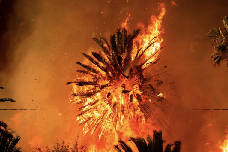
On fire in Pasadena

When I talk about growing up in Pasadena, I oftentimes relate how, instead of snow days, we had smoke days. Days on which we weren’t allowed to go to school because nearby wildfires made the air too unhealthy to breath. I was, of course, happy to stay home and play video games, but the sense of doom radiated around me: from the TV, my Mother’s face, and the powdered ash that seeped through gaps in our window frames.
When I was 10 or 11, I remember driving east on the 210 and seeing flames creep down the foothills of the San Gabriel Mountains. These were mountains which we, and the rest of the city, used as a respite from the urban environment: to hike, to swim, to smoke weed and stare at the stars. Each time a fire rolled through the brush-covered foothills and oak-lined valleys, our favorite trails and creeks would be permanently re-routed (I’ve probably walked on six different versions of Millard Canvyon Falls Trail). In the following Spring months, when torrential rains can fall for weeks at a time, debris flows would spill off the charred mountain faces, sending boulders and parked cars down winding streets through people’s homes.
All of this is to say that anyone who grew up under the shadows of the San Gabriels is used to the spectre of disaster. As Mike Davis has written, Los Angeles is an impossible city in the popular imagination: erected on an arid desert, constantly on the verge of various apocalypses. But even though ecological destruction may seem quotidian to most Angelenos, what has transpired over the past 48 hours of the Palisades and Eaton Fires is unimaginably devastating. Altadena, a neighborhood of 40,000+ residents, has been seemingly wiped off the map.
My family is fortunately safe for now: they live south of the 210 freeway, several miles from the fire’s reach. Pasadena, like many American cities, was strategically divided by a highway in the 60s to segregate the predominantly rich, white, and conservative enclaves from the historically black and hispanic areas of North Pasadena and Altadena. Famously, Pasadena’s public school district was the last in the country (west of the Mississippi) to desegregate in 1970. And when it did, dozens of private schools (one of which I attended) sprung up in the south to accommodate the ensuing white flight. 50+ years later, Pasadena’s public schools, largely north of the 210, are still struggling with funding.
Still, until the recent wave of gentrification, these neighborhoods, filled with modest homes originally sourced from the Sears Catalog, represented an achievable American Dream. These were houses middle-class families could afford to own, set on idyllic tree-lined streets, with easy access to the myriad trails and streams that criss-cross the San Gabriels. It’s no wonder so many residents ignored evacuation orders to save their homes. Unlike the Palisades Fire, which has largely displaced the tremendously wealthy, the Eaton Fire has destroyed a racially and economically diverse neighborhood. For many families, particularly those who’ve been in the area for decades, these houses represented generational wealth; resources to help them send their kids to college or retire comfortably. And now they’ve been subjected to the horrible whims of flying embers.
Given all this, it’s been disappointing to see so many people on social media refer to the 210 freeway as some sort of firewall for the “cultural icons” to the south, as it if were a literal red line:
I know the Huntington Library, Museum, and Botanical Gardens are on the other side of the 210 from the Eaton Fire, but with how fast that fire is moving and the scare with the Getty Villa yesterday, I can't help but be worried about it. It contains the Gutenberg Bible, original Pinkie & Blue Boy 1/2
— Rangegrrl (@rangegrrl.bsky.social) January 8, 2025 at 5:33 PM
I'm not too sympathetic about the loss of privately owned "classic cars." I _am_ worried that if the Eaton Canyon Fire jumps across the 210 Freeway to the west it could threaten cultural icons & historic sites such as the Rose Bowl, the Norton Simon Museum & JPL. [...]
— Mark D. Garfinkel, Ph.D. (@mdgarfinkel.bsky.social) January 8, 2025 at 5:32 PM
I have more thoughts but I’m too tired and sad to formulate them tonight. I pray that the flames subside and the community, north and south of the freeway, will rally to help the recovery. Climate change is too much for us to handle alone.
Links in this post:
- "Millard Canvyon Falls Trail": https://www.alltrails.com/trail/us/california/millard-canyon-falls-trail
- "sending boulders and parked cars down winding streets through people’s homes": https://www.newyorker.com/magazine/1988/09/26/los-angeles-against-the-mountains-i
- "As Mike Davis has written": https://www.goodreads.com/book/show/7852.Ecology_of_Fear
- "are still struggling with funding": rhttps://lailluminator.com/2024/05/19/school-segregation/
- "the recent wave of gentrification": https://www.latimes.com/local/california/la-me-banks-gentrification-20150314-column.html
- "modest homes originally sourced from the Sears Catalog": https://en.wikipedia.org/wiki/Sears_Modern_Homes
- "It’s no wonder so many residents ignored evacuation orders to save their homes": https://www.latimes.com/california/story/2025-01-08/night-of-terror-in-altadena
- "@rangegrrl.bsky.social": https://bsky.app/profile/did:plc:lvyvmmajxaknff2inoqvn2vy?ref_src=embed
- "January 8, 2025 at 5:33 PM": https://bsky.app/profile/did:plc:lvyvmmajxaknff2inoqvn2vy/post/3lfb7tpj5k22w?ref_src=embed
- "@mdgarfinkel.bsky.social": https://bsky.app/profile/did:plc:drjcxo7meyjhk3pbm2cmo6i5?ref_src=embed
- "January 8, 2025 at 5:32 PM": https://bsky.app/profile/did:plc:drjcxo7meyjhk3pbm2cmo6i5/post/3lfb7rmsfzc2b?ref_src=embed